
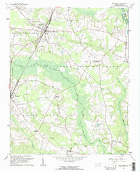
1961 Map of Whitakers
USGS Topo · Published 1964About this map
The town of Whitakers sits at the intersection of county lines and regional transport, straddling the border of Nash and Edgecombe counties. The Atlantic Coast Line railroad dictates the town's linear development, running north-south alongside numerous family-named landmarks and rural congregations. The landscape is defined by the broad, wooded wetlands of Fishing Creek and the meandering path of Swift Creek, which historically influenced the placement of agricultural crossroads like Taylor Crossroads and Cherry Crossroads.
Find a feature on this map
42 named features on this map. Tap any name to fly to it.
Don’t see what you’re looking for? This feature index may not catch every label — zoom into the map to look around manually.
Map Details
Editions of this 1961 Whitakers Map
2 editions found
Other maps of this area

1902 · Rocky Mount
USGS Topo · 1:62,500

1902 · Tarboro
USGS Topo · 1:62,500

1903 · Tarboro
USGS Topo · 1:62,500

1904 · Rocky Mount
USGS Topo · 1:62,500

1953 · Norfolk
USGS Topo · 1:250,000

1953 · Rocky Mount
USGS Topo · 1:250,000

1954 · Rocky Mount
USGS Topo · 1:250,000

1960 · Dawson Crossroads
USGS Topo · 1:24,000

1960 · Draughn
USGS Topo · 1:24,000

1961 · Enfield
USGS Topo · 1:24,000