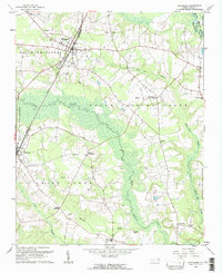
1961 Map of Whitakers
USGS Topo · Published 1964About this map
The Atlantic Coast Line railroad dictates the layout of this eastern North Carolina landscape, running parallel to the border between Nash and Edgecombe counties. The settlement of Whitakers serves as a primary hub where rail infrastructure meets local commerce, while smaller rural junctions like Taylor Crossroads and Cherry Crossroads punctuate the agricultural interior. The map reveals a high density of family-named landmarks and local burial grounds, including the Battle Cem, Temple Cem, and Watson Cem, which provide significant grounding for genealogical research in the North and South Whitakers districts. Drainage patterns are defined by the broad, marshy reaches of Fishing Creek and the meandering Swift Creek, which historically separated the farming tracts. Small community centers are anchored by rural institutions such as the Jerusalem Ch and the Phillips Sch, reflecting the decentralized social structure of the early 1960s.
Find a feature on this map
46 named features on this map. Tap any name to fly to it.
Don’t see what you’re looking for? This feature index may not catch every label — zoom into the map to look around manually.
Map Details
Editions of this 1961 Whitakers Map
2 editions found
Other maps of this area

1902 · Rocky Mount
USGS Topo · 1:62,500

1902 · Tarboro
USGS Topo · 1:62,500

1903 · Tarboro
USGS Topo · 1:62,500

1904 · Rocky Mount
USGS Topo · 1:62,500

1953 · Norfolk
USGS Topo · 1:250,000

1953 · Rocky Mount
USGS Topo · 1:250,000

1954 · Rocky Mount
USGS Topo · 1:250,000

1960 · Dawson Crossroads
USGS Topo · 1:24,000

1960 · Draughn
USGS Topo · 1:24,000

1961 · Whitakers
USGS Topo · 1:24,000