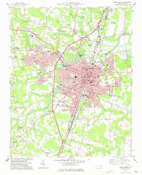
1977 Map of Rocky Mount
USGS Topo · Published 1977About this map
Rocky Mount serves as the focal point of this mid-1970s survey, straddling the Nash Co and Edgecombe Co line along the banks of the Tar River. The city's mid-century expansion is evident in the residential developments of Woodlawn, Sunset, and Winstead, which contrast with the older railroad-oriented infrastructure of South Rocky Mount. The Seaboard Coast Line corridor remains the primary industrial axis, passing through the heart of the city near the Municipal Bldg and Buck Leonard Park.
Find a feature on this map
90 named features on this map. Tap any name to fly to it.
Don’t see what you’re looking for? This feature index may not catch every label — zoom into the map to look around manually.
Map Details
Editions of this 1977 Rocky Mount Map
This is the sole edition of this map. No revisions or reprints were ever made.
Other maps of this area

1902 · Rocky Mount
USGS Topo · 1:62,500

1902 · Tarboro
USGS Topo · 1:62,500

1903 · Tarboro
USGS Topo · 1:62,500

1904 · Rocky Mount
USGS Topo · 1:62,500

1953 · Norfolk
USGS Topo · 1:250,000

1953 · Rocky Mount
USGS Topo · 1:250,000

1954 · Rocky Mount
USGS Topo · 1:250,000

1961 · Whitakers
USGS Topo · 1:24,000

1963 · Red Oak
USGS Topo · 1:24,000

1963 · Drake
USGS Topo · 1:24,000