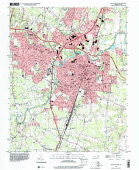
1998 Map of Rocky Mount
USGS Topo · Published 2000About this map
The Tar River flows through the center of this landscape, separating the commercial and civic heart of Rocky Mount from the agricultural and swampy reaches to the south and east. In the late 20th century, the city shows significant expansion west along Sunset Avenue, where Nash General Hosp and the Benvenue Country Club define the suburban frontier. The transit network is dominated by CSX Transportation rails and a grid of municipal streets like Raleigh Road, which anchor the industrial and residential corridors of South Rocky Mount and Rosewood.
Find a feature on this map
84 named features on this map. Tap any name to fly to it.
Don’t see what you’re looking for? This feature index may not catch every label — zoom into the map to look around manually.
Map Details
Editions of this 1998 Rocky Mount Map
This is the sole edition of this map. No revisions or reprints were ever made.
Other maps of this area

1902 · Rocky Mount
USGS Topo · 1:62,500

1902 · Tarboro
USGS Topo · 1:62,500

1903 · Tarboro
USGS Topo · 1:62,500

1904 · Rocky Mount
USGS Topo · 1:62,500

1953 · Norfolk
USGS Topo · 1:250,000

1953 · Rocky Mount
USGS Topo · 1:250,000

1954 · Rocky Mount
USGS Topo · 1:250,000

1961 · Whitakers
USGS Topo · 1:24,000

1963 · Red Oak
USGS Topo · 1:24,000

1963 · Drake
USGS Topo · 1:24,000