
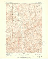
1951 Map of Rockyford SE
USGS Topo · Published 1953About this map
The Pine Ridge Indian Reservation landscape is defined by the winding drainages of Grass Creek and Wounded Knee Creek in the early 1950s. This survey, conducted as part of the Department of the Interior program for the development of the Missouri River Basin, reveals a sparse but established network of essential institutions and water sources. Centered along the valley floor, the Indian School No 11 and St Marys Ch stand as primary landmarks for the local community. The terrain is marked by numerous Windmills, highlighting the critical importance of groundwater management for ranching and settlement in this semi-arid region. The map captures the physical layout of the reservation during a period of transition, documenting the exact placement of these cultural and structural features relative to the intricate contour lines of the plains.
Find a feature on this map
6 named features on this map. Tap any name to fly to it.
Don’t see what you’re looking for? This feature index may not catch every label — zoom into the map to look around manually.
Map Details
Editions of this 1951 Rockyford SE Map
2 editions found
Other maps of this area

1951 · Rockyford SW
USGS Topo · 1:24,000

1951 · Sharps Corner
USGS Topo · 1:24,000

1951 · Rockyford NW
USGS Topo · 1:24,000

1951 · Rockyford
USGS Topo · 1:24,000

1955 · Hot Springs
USGS Topo · 1:250,000

1967 · Pine Ridge NE
USGS Topo · 1:24,000

1967 · Manderson
USGS Topo · 1:24,000

1967 · Oglala
USGS Topo · 1:24,000

1981 · Evergreen
USGS Topo · 1:25,000

1985 · Pine Ridge
USGS Topo · 1:100,000