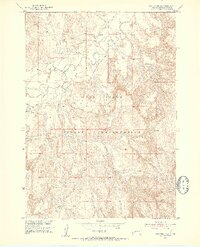
1951 Map of Rockyford SW
USGS Topo · Published 1953About this map
The White River winds through the northern portion of this 1951 survey, carving a path through the distinct topography of the Pine Ridge Indian Reservation. This map, produced as part of the Department of the Interior program for the development of the Missouri River Basin, documents the sparse landscape of Oglala Lakota County during the early post-war era. The terrain is dominated by the Pine Ridge formation, where complex contour lines reveal a heavily eroded environment of ridges and draws. Evidence of local settlement is limited to isolated structures and a single Cem near the river, while the drainage of West Horse Creek provides a secondary focal point in the northwest. The map captures a moment of transition when light-duty and unimproved dirt roads were the primary means of navigating this expansive reservation territory.
Find a feature on this map
6 named features on this map. Tap any name to fly to it.
Don’t see what you’re looking for? This feature index may not catch every label — zoom into the map to look around manually.
Map Details
Editions of this 1951 Rockyford SW Map
2 editions found
Other maps of this area

1951 · Rockyford SW
USGS Topo · 1:24,000

1951 · Rockyford NW
USGS Topo · 1:24,000

1951 · Willow Creek NE
USGS Topo · 1:24,000

1951 · Rockyford
USGS Topo · 1:24,000

1951 · Rockyford SE
USGS Topo · 1:24,000

1955 · Hot Springs
USGS Topo · 1:250,000

1967 · Pine Ridge NE
USGS Topo · 1:24,000

1967 · Oglala
USGS Topo · 1:24,000

1967 · Slim Butte NE
USGS Topo · 1:24,000

1967 · Willow Creek
USGS Topo · 1:24,000