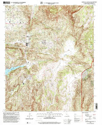
1997 Map of Rodriguez Mountain
USGS Topo · Published 2000About this map
Rincon Indian Reservation and the San Pasqual Indian Reservation define much of this inland landscape, where steep terrain transitions into fertile valleys and expansive flats. In the late 1990s, the area retained a rural character, marked by the presence of significant agricultural properties like Melrose Ranch and Vineyard Ranch. The topography is dominated by the massive profile of Rodriguez Mountain and Paradise Mountain, which drop into canyon systems carved by Hellhole Creek and Guejito Creek. In the southwest corner, Lake Wohlford serves as a major hydrological anchor, while high-altitude areas like Cienaga Flats and Sycamore Flats suggest a history of seasonal grazing and water management. This survey captures a moment before more intensive development, preserving the footprints of isolated homesteads and a remote Landing Strip nestled among the foothills.
Find a feature on this map
29 named features on this map. Tap any name to fly to it.
Don’t see what you’re looking for? This feature index may not catch every label — zoom into the map to look around manually.
Map Details
Editions of this 1997 Rodriguez Mountain Map
This is the sole edition of this map. No revisions or reprints were ever made.
Other maps of this area

1893 · Escondido
USGS Topo · 1:62,500

1901 · Escondido
USGS Topo · 1:62,500

1901 · San Luis Rey
USGS Topo · 1:125,000

1903 · Ramona
USGS Topo · 1:125,000

1904 · Southern California Sheet No. 2
USGS Topo · 1:250,000

1939 · Palomar Mountain
USGS Topo · 1:62,500

1942 · Temecula
USGS Topo · 1:62,500

1942 · Escondido
USGS Topo · 1:62,500

1942 · Ramona
USGS Topo · 1:62,500

1947 · Ramona
USGS Topo · 1:62,500