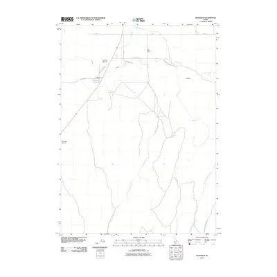
2010 Map of Rogerson
USGS Topo · Published 2010About this map
Rogerson serves as the central hub of this Twin Falls County landscape, positioned along the corridor of Old Hwy 93. The map reveals a land defined by its water management and ranching roots, with infrastructure like A Lateral supporting agricultural operations at Deep Creek Meadows Ranch and Duck Springs Ranch. The terrain is characterized by a network of drainage systems, including the winding Cottonwood Creek and the notable South Fork Deep Creek, which cut through the high desert topography. Numerous water sources such as Rogerson Spring, Dan Spring, and Emerson Spring are documented, highlighting the vital locations for livestock and early settlers in this arid environment. Elevation features like Flatiron and the deep cut of Mccongle Canyon provide a detailed look at the geographic character of the region as it appeared in the early 21st century.
Find a feature on this map
22 named features on this map. Tap any name to fly to it.
Don’t see what you’re looking for? This feature index may not catch every label — zoom into the map to look around manually.
Map Details
Editions of this 2010 Rogerson Map
This is the sole edition of this map. No revisions or reprints were ever made.
Other maps of this area

1955 · Twin Falls
USGS Topo · 1:250,000

1958 · Twin Falls
USGS Topo · 1:250,000

1965 · Hollister SW
USGS Topo · 1:24,000

1965 · Hollister
USGS Topo · 1:24,000

1965 · Mc Mullen Basin
USGS Topo · 1:24,000

1977 · Big Creek Ranch
USGS Topo · 1:24,000

1977 · Rogerson
USGS Topo · 1:24,000

1977 · Magic Hot Springs
USGS Topo · 1:24,000

1977 · Salmon Butte
USGS Topo · 1:24,000

1978 · Hopper Gulch
USGS Topo · 1:24,000