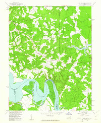
1949 Map of Rollins Fork
USGS Topo · Published 1961About this map
The Rappahannock River dominates the southern landscape of this Virginia survey, where the borders of King George, Westmoreland, and Essex counties converge. This post-war era view captures a rural community defined by scattered settlements and small crossroads. Rollins Fork serves as a central point, surrounded by a network of local churches including Howards View Ch, Grace Ch, and Shiloh Ch.
Find a feature on this map
26 named features on this map. Tap any name to fly to it.
Don’t see what you’re looking for? This feature index may not catch every label — zoom into the map to look around manually.
Map Details
Editions of this 1949 Rollins Fork Map
This is the sole edition of this map. No revisions or reprints were ever made.
Other maps of this area

1889 · Fredericksburg
USGS Topo · 1:125,000

1892 · Fredericksburg
USGS Topo · 1:125,000

1892 · Montross
USGS Topo · 1:62,500

1894 · Wicomico
USGS Topo · 1:62,500

1894 · Fredericksburg
USGS Topo · 1:125,000

1895 · Wicomico
USGS Topo · 1:62,500

1895 · Nomini
USGS Topo · 1:125,000
1895 · Montross
USGS Topo · 1:62,500

1898 · Nomini
USGS Topo · 1:125,000
1902 · Wicomico
USGS Topo · 1:62,500