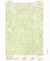
1984 Map of Roman Nose Mtn
USGS Topo · Published 1984About this map
The rugged divide between the Siuslaw River and the Smith River drainage dominates this Oregon landscape, anchored by the high peak of Roman Nose Mtn. Surveyed in the late 1970s and published in the early 1980s, the map reveals the complex drainage patterns of the Siuslaw National Forest, where steep ridges separate waterways like Kentucky Creek and Leopold Creek. A small Cem and Quarry suggest the human footprint within these timberlands, while the Southern Pacific line follows the river corridor at the northern edge. Recreational development is evident at the Whittaker Creek Recreation Site and Linslaw County Park, marking the transition from industrial forest use to public access during this era. The boundary between Lane Co and Douglas Co cuts across these ridges, tracing the natural topography of the Coast Range.
Find a feature on this map
21 named features on this map. Tap any name to fly to it.
Don’t see what you’re looking for? This feature index may not catch every label — zoom into the map to look around manually.
Map Details
Editions of this 1984 Roman Nose Mtn Map
This is the sole edition of this map. No revisions or reprints were ever made.
Other maps of this area

1918 · Mapleton
USGS Topo · 1:48,000

1919 · Earl
USGS Topo · 1:48,000

1940 · Mapleton
USGS Topo · 1:62,500

1941 · Blachly
USGS Topo · 1:62,500

1942 · Blachly
USGS Topo · 1:62,500

1942 · Roman Nose Mtn
USGS Topo · 1:62,500

1943 · Goodwin Peak
USGS Topo · 1:62,500

1945 · Mapleton
USGS Topo · 1:62,500

1945 · Roman Nose Mtn
USGS Topo · 1:62,500

1953 · Salem
USGS Topo · 1:250,000