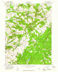
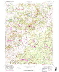
1957 Map of Roosevelt
USGS Topo · Published 1961About this map
The planned community of Roosevelt sits at the heart of this mid-century landscape, where the borders of Mercer and Monmouth counties meet. This survey shows a post-war rural infrastructure defined by agricultural legacies and the beginning of suburban shifts, with the Sewage Disposal plant near Assunpink Creek marking modern utility expansion. A dense network of local routes, including the Perrineville-Mercer County Road and Sweetman Lane, connects historic hamlets like Stone Tavern, Clarksburg, and Bairdsville.
Find a feature on this map
44 named features on this map. Tap any name to fly to it.
Don’t see what you’re looking for? This feature index may not catch every label — zoom into the map to look around manually.
Map Details
Editions of this 1957 Roosevelt Map
5 editions found
Other maps of this area

1888 · Bordentown
USGS Topo · 1:62,500

1888 · New Brunswick
USGS Topo · 1:62,500

1888 · Princeton
USGS Topo · 1:62,500

1888 · Cassville
USGS Topo · 1:62,500

1893 · Bordentown
USGS Topo · 1:62,500

1893 · New Brunswick
USGS Topo · 1:62,500

1894 · Princeton
USGS Topo · 1:62,500

1894 · Cassville
USGS Topo · 1:62,500

1900 · Cassville
USGS Topo · 1:62,500

1901 · New Brunswick
USGS Topo · 1:62,500
Featured Places
- Jackson Township, NJ
- Manalapan Township, NJ
- Freehold Township, NJ
- East Windsor Township, NJ
- Millstone Township, NJ