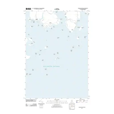
2011 Map of Roque Bluffs
USGS Topo · Published 2011About this map
Roque Bluffs and the coastal village of Starboard anchor this maritime survey of the Washington County shoreline. The landscape is defined by its transition from the mouth of the Englishman River to the open Atlantic Ocean. Natural features dominate the coastline, including the freshwater Shoppee Pond separated from the salt air by Roque Bluffs Beach. The archipelago scattered offshore features numerous named ledges and islands such as The Brothers, Foster Island, and the Scabby Islands, illustrating a coastline where water and granite landforms are inextricably linked. Inland, modest elevations like Johnson Mountain rise above the coastal roads, while local routes like Roque Bluffs Rd and Starboard Creek Rd provide access to the various points and coves that have historically supported the area's maritime identity.
Find a feature on this map
64 named features on this map. Tap any name to fly to it.
Don’t see what you’re looking for? This feature index may not catch every label — zoom into the map to look around manually.
Map Details
Editions of this 2011 Roque Bluffs Map
This is the sole edition of this map. No revisions or reprints were ever made.
Other maps of this area

1918 · Machias
USGS Topo · 1:62,500

1921 · Great Wass Island
USGS Topo · 1:62,500

1921 · Columbia Falls
USGS Topo · 1:62,500

1941 · Columbia Falls
USGS Topo · 1:62,500

1941 · Machias
USGS Topo · 1:62,500

1942 · Columbia Falls
USGS Topo · 1:62,500

1948 · Jonesport
USGS Topo · 1:24,000

1948 · Roque Bluffs
USGS Topo · 1:24,000
1948 · Whitneyville
USGS Topo · 1:24,000
1949 · Machias
USGS Topo · 1:24,000