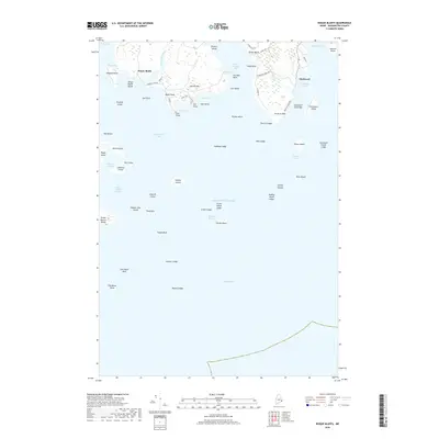
2018 Map of Roque Bluffs
USGS Topo · Published 2018About this map
Roque Bluffs and Starboard anchor this coastal landscape, where the Englishman River meets the sea along the jagged shoreline of Washington County. This survey reveals a complex network of maritime landforms, including the prominent Johnson Mtn and the sweeping crescent of Roque Bluffs Beach. The waters are filled with named hazards and navigational landmarks such as Gull Rock, Shag Ledge, and Pierson Ledge, illustrating the challenging conditions of the Englishman Bay area.
Find a feature on this map
75 named features on this map. Tap any name to fly to it.
Don’t see what you’re looking for? This feature index may not catch every label — zoom into the map to look around manually.
Map Details
Editions of this 2018 Roque Bluffs Map
This is the sole edition of this map. No revisions or reprints were ever made.
Other maps of this area

1918 · Machias
USGS Topo · 1:62,500

1921 · Great Wass Island
USGS Topo · 1:62,500

1921 · Columbia Falls
USGS Topo · 1:62,500

1941 · Columbia Falls
USGS Topo · 1:62,500

1941 · Machias
USGS Topo · 1:62,500

1942 · Columbia Falls
USGS Topo · 1:62,500

1948 · Jonesport
USGS Topo · 1:24,000

1948 · Roque Bluffs
USGS Topo · 1:24,000
1948 · Whitneyville
USGS Topo · 1:24,000
1949 · Machias
USGS Topo · 1:24,000