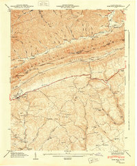
1948 Map of Rose Hill
USGS Topo · Published 1949About this map
Cumberland Mountain stands as a massive diagonal barrier across this 1948 survey, separating the high ridges of Black Mountain from the lower valley floors. The landscape is defined by its gaps and transportation routes, most notably where the Louisville and Nashville railroad and the Daniel Boone Trail parallel Poor Valley Ridge. This era shows a well-established rural infrastructure of family-named landmarks and local processing sites, including Edda Mill and Carrol Mill.
Find a feature on this map
94 named features on this map. Tap any name to fly to it.
Don’t see what you’re looking for? This feature index may not catch every label — zoom into the map to look around manually.
Map Details
Editions of this 1948 Rose Hill Map
This is the sole edition of this map. No revisions or reprints were ever made.
Other maps of this area

1887 · Jonesville
USGS Topo · 1:125,000

1891 · Jonesville
USGS Topo · 1:125,000

1903 · Harlan
USGS Topo · 1:48,000

1916 · Harlan
USGS Topo · 1:48,000

1916 · Nolansburg
USGS Topo · 1:48,000

1919 · Nolansburg
USGS Topo · 1:62,500

1919 · Harlan
USGS Topo · 1:62,500

1932 · Hagan
USGS Topo · 1:62,500
1935 · Ewing
USGS Topo · 1:24,000

1935 · Hubbard Springs
USGS Topo · 1:24,000