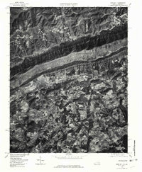
1976 Map of Rose Hill
USGS Topo · Published 1981About this map
Cumberland Mountain dominates the northern half of this Lee County landscape, creating a formidable geological barrier that channeled early Appalachian settlement and transport into the valley below. In the mid-1970s, the community of Rose Hill and nearby Henegartown served as central points for local commerce and rural life. The orthophoto imagery reveals the complex patchwork of small-scale agricultural clearings that defined the region's land use during this era. High-altitude drainage systems like Martins Fork and Cranks Creek flow northward into Kentucky, while Martin Creek and Hardy Creek drain the southern valley floor. The map captures a moment when smaller named locales such as Hagan, Sampson, and Liggett maintained distinct identities along the mountain's base and the primary roadway corridors.
Find a feature on this map
11 named features on this map. Tap any name to fly to it.
Don’t see what you’re looking for? This feature index may not catch every label — zoom into the map to look around manually.
Map Details
Editions of this 1976 Rose Hill Map
This is the sole edition of this map. No revisions or reprints were ever made.
Other maps of this area

1887 · Jonesville
USGS Topo · 1:125,000

1891 · Jonesville
USGS Topo · 1:125,000

1903 · Harlan
USGS Topo · 1:48,000

1916 · Harlan
USGS Topo · 1:48,000

1916 · Nolansburg
USGS Topo · 1:48,000

1919 · Nolansburg
USGS Topo · 1:62,500

1919 · Harlan
USGS Topo · 1:62,500

1932 · Hagan
USGS Topo · 1:62,500
1935 · Ewing
USGS Topo · 1:24,000

1935 · Hubbard Springs
USGS Topo · 1:24,000