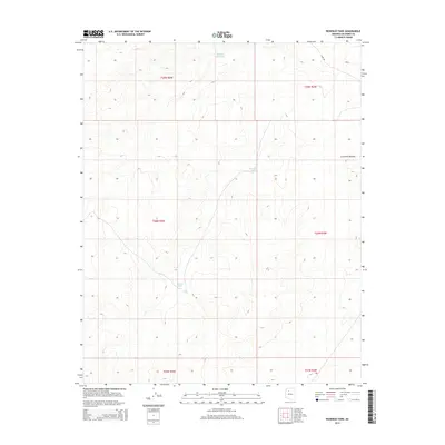
2014 Map of Rosebud Tank
USGS Topo · Published 2014About this map
The Coconino Plateau defines this high-desert landscape in northern Arizona, where the availability of water is the primary factor in land management. This 2014 survey documents a network of critical catchment points, including Rosebud Tank and Broken Axle Tank, which serve as vital resources for livestock and wildlife across these vast public lands. The terrain is marked by the systematic layout of the Public Land Survey System, with township boundaries like t28n r3w and t29n r2w delineating the remote territory. Access is limited to a handful of unpaved routes, most notably Sunu Rd, which cuts through the northeastern corner of the quadrangle. For those studying the arid landscape of Coconino County, the placement of features like Blanko Tank illustrates the ongoing reliance on traditional water-harvesting infrastructure in the modern era.
Find a feature on this map
11 named features on this map. Tap any name to fly to it.
Don’t see what you’re looking for? This feature index may not catch every label — zoom into the map to look around manually.
Map Details
Editions of this 2014 Rosebud Tank Map
This is the sole edition of this map. No revisions or reprints were ever made.
Other maps of this area

1886 · Chino
USGS Topo · 1:250,000

1891 · Chino
USGS Topo · 1:250,000

1948 · Williams
USGS Topo · 1:250,000

1954 · Williams
USGS Topo · 1:250,000

1956 · Williams
USGS Topo · 1:250,000

1960 · Williams
USGS Topo · 1:250,000

1961 · Williams
USGS Topo · 1:250,000
1979 · Box K Ranch
USGS Topo · 1:24,000

1979 · Little Harpo Canyon
USGS Topo · 1:24,000

1980 · Hazen Hole Tank
USGS Topo · 1:24,000