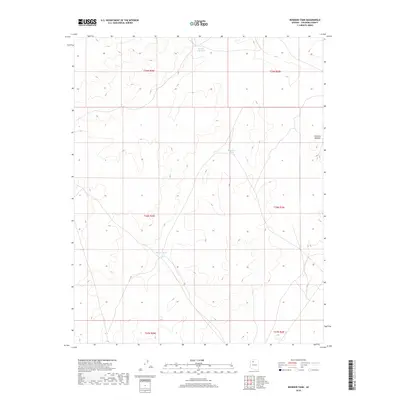
2018 Map of Rosebud Tank
USGS Topo · Published 2018About this map
The Coconino Plateau defines the character of this northern Arizona landscape, where the scarcity of water is reflected in the strategically placed catchments that dot the terrain. These artificial watering points, such as Rosebud Tank and Broken Axle Tank, are essential infrastructure for the high-desert environment, supporting livestock or local wildlife where natural springs are rare. The map detail highlights the survey grid of the Public Land Survey System, showing the township and range lines like t28n r2w that organized the region's ranching and land use. The presence of Blanko Tank further underscores a historical pattern of human adaptation to a dry plateau, where every named water feature represents a vital landmark in an otherwise wide and undulating landscape.
Find a feature on this map
10 named features on this map. Tap any name to fly to it.
Don’t see what you’re looking for? This feature index may not catch every label — zoom into the map to look around manually.
Map Details
Editions of this 2018 Rosebud Tank Map
This is the sole edition of this map. No revisions or reprints were ever made.
Other maps of this area

1886 · Chino
USGS Topo · 1:250,000

1891 · Chino
USGS Topo · 1:250,000

1948 · Williams
USGS Topo · 1:250,000

1954 · Williams
USGS Topo · 1:250,000

1956 · Williams
USGS Topo · 1:250,000

1960 · Williams
USGS Topo · 1:250,000

1961 · Williams
USGS Topo · 1:250,000
1979 · Box K Ranch
USGS Topo · 1:24,000

1979 · Little Harpo Canyon
USGS Topo · 1:24,000

1980 · Hazen Hole Tank
USGS Topo · 1:24,000