
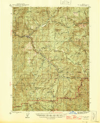
1897 Map of Roseburg
USGS Topo · Published 1897About this map
Roseburg serves as the focal point of this late 19th-century landscape, where the Oregon and California RR traces a path through the river valleys. The terrain is defined by the winding course of the Umpqua River and its tributaries, which carved out fertile pockets like Garden Valley, Lookingglass Valley, and Happy Valley. Settlement patterns at this time were closely tied to these natural corridors, with established towns such as Oakland, Wilbur, and Myrtle Creek positioned along the rail line and watercourses.
Find a feature on this map
102 named features on this map. Tap any name to fly to it.
Don’t see what you’re looking for? This feature index may not catch every label — zoom into the map to look around manually.
Map Details
Editions of this 1897 Roseburg Map
This is the sole edition of this map. No revisions or reprints were ever made.
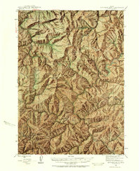
Other maps of this area

1891 · Ashland
USGS Topo · 1:250,000

1893 · Ashland
USGS Topo · 1:250,000

1897 · Ashland
USGS Topo · 1:250,000

1900 · Roseburg
USGS Topo · 1:125,000

1904 · Riddle
USGS Topo · 1:125,000

1928 · Sitkum
USGS Topo · 1:125,000

1935 · Lowell
USGS Topo · 1:96,000

1942 · Lowell
USGS Topo · 1:125,000
1944 · Tiller
USGS Topo · 1:62,500
1946 · Dutchman Butte
USGS Topo · 1:62,500