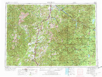
1958 Map of Roseburg
USGS Topo · Published 1973About this map
Roseburg serves as the primary hub in this late-midcentury topographic portrait of the western Cascades and the Umpqua River valley. The landscape is defined by the heavy presence of public timberlands, including the Umpqua National Forest and Willamette National Forest, interspersed with peak names like Bohemia Mountain and Roman Nose Mountain. This era shows the developed transportation corridor of Interstate 5 and the Southern Pacific railroad facilitating trade between settlements like Cottage Grove and Sutherlin. To the east, the map details the high mountain recreation and conservation areas, from the Three Sisters Wilderness down to the north rim of Crater Lake National Park. The map documents significant hydrological features, including the Lookout Point Reservoir and Hills Creek Reservoir, alongside natural high-altitude waters such as Waldo Lake and Odell Lake, reflecting the post-war focus on water management and resource protection in the Pacific Northwest.
Find a feature on this map
125 named features on this map. Tap any name to fly to it.
Don’t see what you’re looking for? This feature index may not catch every label — zoom into the map to look around manually.
Map Details
Editions of this 1958 Roseburg Map
4 editions found

Other maps of this area

1889 · Klamath
USGS Topo · 1:250,000

1891 · Ashland
USGS Topo · 1:250,000

1893 · Ashland
USGS Topo · 1:250,000

1894 · Klamath
USGS Topo · 1:250,000

1896 · Coos Bay
USGS Topo · 1:125,000

1897 · Roseburg
USGS Topo · 1:125,000

1897 · Ashland
USGS Topo · 1:250,000

1898 · Coos Bay
USGS Topo · 1:125,000

1899 · Port Orford
USGS Topo · 1:125,000

1900 · Roseburg
USGS Topo · 1:125,000