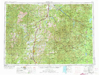
1958 Map of Roseburg
USGS Topo · Published 1973About this map
Roseburg serves as the central hub of this mid-century look at Southern Oregon, situated where Interstate 5 parallels the South Umpqua River. The landscape transitions from the populated valley floor to the dense timberlands of the Cascade Range, where the Willamette National Forest and Umpqua National Forest dominate the eastern half of the sheet. The economy and transit of the era are clearly defined by the Southern Pacific railroad line, which connects towns like Cottage Grove, Drain, and Myrtle Creek. To the east, the map details the high-altitude geography of Crater Lake National Park and the Three Sisters Wilderness, alongside major reservoirs such as Lookout Point Reservoir and Hills Creek Reservoir, reflecting the importance of water management and recreation in the post-war Cascades.
Find a feature on this map
39 named features on this map. Tap any name to fly to it.
Don’t see what you’re looking for? This feature index may not catch every label — zoom into the map to look around manually.
Map Details
Editions of this 1958 Roseburg Map
4 editions found

Other maps of this area

1889 · Klamath
USGS Topo · 1:250,000

1891 · Ashland
USGS Topo · 1:250,000

1893 · Ashland
USGS Topo · 1:250,000

1894 · Klamath
USGS Topo · 1:250,000

1896 · Coos Bay
USGS Topo · 1:125,000

1897 · Roseburg
USGS Topo · 1:125,000

1897 · Ashland
USGS Topo · 1:250,000

1898 · Coos Bay
USGS Topo · 1:125,000

1899 · Port Orford
USGS Topo · 1:125,000

1900 · Roseburg
USGS Topo · 1:125,000