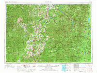
1958 Map of Roseburg
USGS Topo · Published 1967About this map
Roseburg serves as the focal point for this Southwest Oregon landscape, situated at the confluence of the North Umpqua River and South Umpqua River. During the mid-twentieth century, the region's economy and movement were defined by the Southern Pacific railroad corridor and Highway 99, linking timber-rich settlements like Sutherlin, Oakland, and Myrtle Creek. The map illustrates a massive transition from the valley floors to the high volcanic peaks of the Cascade Range, where Diamond Peak and Mount Thielsen overlook a vast network of water resources. Significant post-war infrastructure is evident in the presence of the Hills Creek Reservoir and Toketee Reservoir, highlighting the era's focus on hydroelectric and water management projects. To the east, the boundary of Crater Lake National Park meets the Umpqua National Forest, preserving the wilderness character around iconic high-altitude bodies of water such as Waldo Lake and Odell Lake.
Find a feature on this map
99 named features on this map. Tap any name to fly to it.
Don’t see what you’re looking for? This feature index may not catch every label — zoom into the map to look around manually.
Map Details
Editions of this 1958 Roseburg Map
4 editions found

Other maps of this area

1889 · Klamath
USGS Topo · 1:250,000

1891 · Ashland
USGS Topo · 1:250,000

1893 · Ashland
USGS Topo · 1:250,000

1894 · Klamath
USGS Topo · 1:250,000

1896 · Coos Bay
USGS Topo · 1:125,000

1897 · Roseburg
USGS Topo · 1:125,000

1897 · Ashland
USGS Topo · 1:250,000

1898 · Coos Bay
USGS Topo · 1:125,000

1899 · Port Orford
USGS Topo · 1:125,000

1900 · Roseburg
USGS Topo · 1:125,000