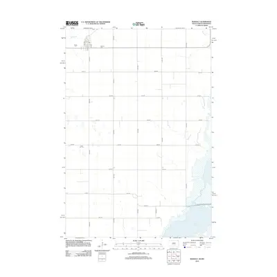
2012 Map of Rosholt
USGS Topo · Published 2012About this map
Lake Traverse defines the southeastern corner of this landscape in the Lake Traverse District, where the South Dakota and Minnesota borders meet. The terrain is structured by a precise grid of rural roads such as 475th Ave and 109th St, reflecting the organized agricultural development of Roberts County. Near the northern border, the community layout is marked by residential streets like Emil Ave and Dahl Ave. For those researching local family history, the map identifies three significant burial sites: Hillside Cem, Bethania Cem, and Saint Peter Cem. The drainage patterns are dominated by Big Slough in the north, illustrating the prairie pothole and wetland character of the region before the waters collect in the larger basin of the lake.
Find a feature on this map
21 named features on this map. Tap any name to fly to it.
Don’t see what you’re looking for? This feature index may not catch every label — zoom into the map to look around manually.
Map Details
Editions of this 2012 Rosholt Map
This is the sole edition of this map. No revisions or reprints were ever made.
Other maps of this area

1915 · White Rock
USGS Topo · 1:62,500

1916 · Peever
USGS Topo · 1:62,500

1916 · Beardsley
USGS Topo · 1:62,500

1917 · New Effington
USGS Topo · 1:62,500

1918 · Peever
USGS Topo · 1:62,500

1918 · White Rock
USGS Topo · 1:62,500

1918 · Beardsley
USGS Topo · 1:62,500

1953 · Milbank
USGS Topo · 1:250,000

1958 · Milbank
USGS Topo · 1:250,000
1971 · Peever NE
USGS Topo · 1:24,000