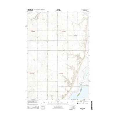
2015 Map of Rosholt
USGS Topo · Published 2015About this map
Rosholt stands at the northwestern corner of this Roberts County landscape, where the prairie grid of South Dakota meets the border of Minnesota. This 2015 study illustrates a quintessential Midwestern agricultural pattern, with a dense network of township roads like 106th St and 107th St dividing the land into regular sections. The area’s history is reflected in several community landmarks, including Hillside Cem, Bethania Cem, and Saint Peter Cem, which serve as primary points of interest for those researching local family history. To the southeast, the terrain descends toward the significant waters of Lake Traverse, which defines the boundary line between South Dakota and Minnesota. Near the town site, Big Slough winds through the northern sections, indicating the drainage patterns that have historically influenced land use and settlement in this border region.
Find a feature on this map
24 named features on this map. Tap any name to fly to it.
Don’t see what you’re looking for? This feature index may not catch every label — zoom into the map to look around manually.
Map Details
Editions of this 2015 Rosholt Map
This is the sole edition of this map. No revisions or reprints were ever made.
Other maps of this area

1915 · White Rock
USGS Topo · 1:62,500

1916 · Peever
USGS Topo · 1:62,500

1916 · Beardsley
USGS Topo · 1:62,500

1917 · New Effington
USGS Topo · 1:62,500

1918 · Peever
USGS Topo · 1:62,500

1918 · White Rock
USGS Topo · 1:62,500

1918 · Beardsley
USGS Topo · 1:62,500

1953 · Milbank
USGS Topo · 1:250,000

1958 · Milbank
USGS Topo · 1:250,000
1971 · Peever NE
USGS Topo · 1:24,000