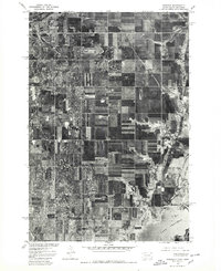
1977 Map of Rosholt
USGS Topo · Published 1979About this map
Rosholt sits at the northwestern corner of this 1970s orthophotoquad, serving as a primary settlement within a vast patchwork of agricultural fields along the South Dakota and Minnesota border. Produced in cooperation with the Bureau of Indian Affairs, the imagery reveals the rigid section lines and drainage patterns that define this rural landscape near the northern reaches of Lake Traverse. The southeast corner of the map is dominated by the waters of the lake and the adjacent Mud Lake, where the natural shoreline contrasts sharply with the geometric precision of the surrounding farms. This specific survey provides a clear view of the land-use patterns and rural infrastructure in Roberts County during the late twentieth century, capturing the area before modern development altered the local farmsteads.
Find a feature on this map
3 named features on this map. Tap any name to fly to it.
Don’t see what you’re looking for? This feature index may not catch every label — zoom into the map to look around manually.
Map Details
Editions of this 1977 Rosholt Map
This is the sole edition of this map. No revisions or reprints were ever made.
Other maps of this area

1915 · White Rock
USGS Topo · 1:62,500

1916 · Peever
USGS Topo · 1:62,500

1916 · Beardsley
USGS Topo · 1:62,500

1917 · New Effington
USGS Topo · 1:62,500

1918 · Peever
USGS Topo · 1:62,500

1918 · White Rock
USGS Topo · 1:62,500

1918 · Beardsley
USGS Topo · 1:62,500

1953 · Milbank
USGS Topo · 1:250,000

1958 · Milbank
USGS Topo · 1:250,000
1971 · Peever NE
USGS Topo · 1:24,000