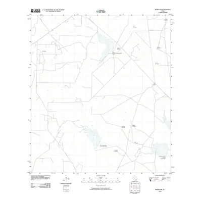
2010 Map of Rosita NW
USGS Topo · Published 2010About this map
San Diego Creek meanders through this portion of Duval County, defining a landscape shaped by ranching and essential water management. The area is marked by numerous named landmarks such as Blanca Windmill, La Mota Windmill, and Venado Windmill, which signify the importance of groundwater in this arid South Texas region. Small settlements and operational hubs like San Cajo and Cook Ranch anchor the local geography, connected by a network of rural routes including Old Seven Sisters Rd and Co Rd 407. In the northern section, Chiltipin Creek cuts across the terrain near the North Windmill. This 2010 survey also highlights significant infrastructure from the Soil Conservation Service, specifically the Soil Conservation Service Site 1 Dam and Site 3, illustrating the systematic efforts to control runoff and support the agricultural economy of the brush country.
Find a feature on this map
22 named features on this map. Tap any name to fly to it.
Don’t see what you’re looking for? This feature index may not catch every label — zoom into the map to look around manually.
Map Details
Editions of this 2010 Rosita NW Map
This is the sole edition of this map. No revisions or reprints were ever made.
Other maps of this area

1920 · Mikeska
USGS Topo · 1:125,000

1937 · Loma Alta
USGS Topo · 1:62,500

1953 · Crystal City
USGS Topo · 1:250,000

1955 · Crystal City
USGS Topo · 1:250,000

1956 · Rosita Ranch
USGS Topo · 1:62,500

1956 · Freer
USGS Topo · 1:62,500

1956 · Laredo
USGS Topo · 1:250,000

1961 · Crystal City
USGS Topo · 1:250,000

1968 · Crystal City
USGS Topo · 1:250,000
1968 · Rosita
USGS Topo · 1:24,000