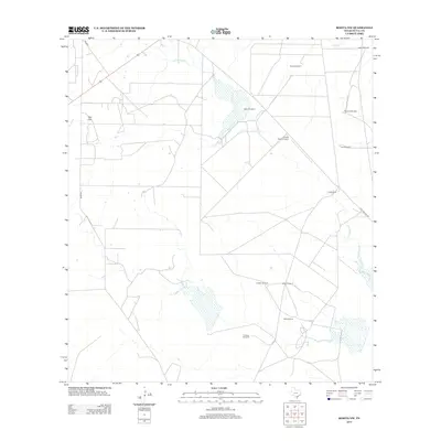
2013 Map of Rosita NW
USGS Topo · Published 2013About this map
San Cajo and Cook Ranch sit within a South Texas landscape defined by an extensive network of water-management landmarks and ranching infrastructure. This portion of Duval County is characterized by numerous named wind pumps, including Walker Windmill, Blanca Windmill, and Canogas Windmill, which reflect the region's reliance on groundwater for livestock and rural settlement. The drainage patterns of San Diego Cr and Chiltipin Cr weave through the terrain, supporting seasonal wetlands and intermittent water bodies. Modern connectivity is facilitated by FM 2359 and the aptly named Old 7 Sisters Rd, while the Temple Ranch Airport provides a point of aerial access to these sprawling ranch lands. The map serves as a record of late 20th and early 21st-century land use, where family-named features like Cavazos Windmill and Venado Windmill preserve local lineage on the land.
Find a feature on this map
17 named features on this map. Tap any name to fly to it.
Don’t see what you’re looking for? This feature index may not catch every label — zoom into the map to look around manually.
Map Details
Editions of this 2013 Rosita NW Map
This is the sole edition of this map. No revisions or reprints were ever made.
Other maps of this area

1920 · Mikeska
USGS Topo · 1:125,000

1937 · Loma Alta
USGS Topo · 1:62,500

1953 · Crystal City
USGS Topo · 1:250,000

1955 · Crystal City
USGS Topo · 1:250,000

1956 · Rosita Ranch
USGS Topo · 1:62,500

1956 · Freer
USGS Topo · 1:62,500

1956 · Laredo
USGS Topo · 1:250,000

1961 · Crystal City
USGS Topo · 1:250,000

1968 · Crystal City
USGS Topo · 1:250,000
1968 · Rosita
USGS Topo · 1:24,000