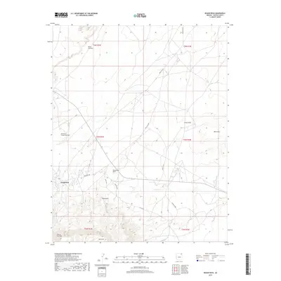
2018 Map of Rough Rock
USGS Topo · Published 2018About this map
Rough Rock serves as the primary settlement hub in this high-desert region of the Navajo Nation, where the landscape is defined by dramatic geological markers and traditional land divisions. Notable landforms like White Top Mesa, the uniquely named Little Ice Cream Cone Hill, and Bitshuitsos Butte dominate the northern and central terrain. The southern portion of the map is shaped by the deep drainage of Trading Post Wash, which flows beneath the prominent elevations of Yellow Point and Yale Point. Transportation through this Shiprock Agency territory relies on a network of tribal and local routes, including Indian Rte 8066 and Co Rd C504, connecting the scattered homesteads and mesas. The presence of Carson Mesa and the White Hills to the east illustrates the complex topography of the Apache County highlands during this era of modern USGS survey.
Find a feature on this map
21 named features on this map. Tap any name to fly to it.
Don’t see what you’re looking for? This feature index may not catch every label — zoom into the map to look around manually.
Map Details
Editions of this 2018 Rough Rock Map
This is the sole edition of this map. No revisions or reprints were ever made.
Other maps of this area

1892 · Canyon De Chelly
USGS Topo · 1:250,000

1954 · Shiprock
USGS Topo · 1:250,000

1958 · Shiprock
USGS Topo · 1:250,000

1959 · Shiprock
USGS Topo · 1:250,000

1968 · Rock Point SW
USGS Topo · 1:24,000

1968 · Tah Chee Wash
USGS Topo · 1:24,000
1968 · White Point
USGS Topo · 1:24,000

1968 · Many Farms SW
USGS Topo · 1:24,000

1968 · Windy Valley
USGS Topo · 1:24,000
1968 · Sweetwater Mesa
USGS Topo · 1:24,000