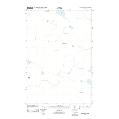
2011 Map of Round Mountain
USGS Topo · Published 2011About this map
Round Mountain and the surrounding high peaks of northern Maine define this interior landscape, documented by the U.S. Geological Survey in 2011. The terrain is characterized by a series of prominent elevations, including Peaked Mountain, Spectacle Mountain, and Middle Mountain, which divide the region's complex drainage network. A dense system of water bodies is scattered throughout the township, from the larger Rowe Lake in the north to smaller, sequestered basins like Leonard Pond and Lost Pond. Numerous brooks, such as Chase Brook and Lovejoy Brook, navigate the spaces between the ridges, illustrating the natural water shed patterns of this undeveloped timberland. The map reveals a place where geography is dictated by these natural landmarks rather than human settlement, preserving the character of the Maine woods as a network of ridges, ponds, and interconnected waterways.
Find a feature on this map
24 named features on this map. Tap any name to fly to it.
Don’t see what you’re looking for? This feature index may not catch every label — zoom into the map to look around manually.
Map Details
Editions of this 2011 Round Mountain Map
This is the sole edition of this map. No revisions or reprints were ever made.
Other maps of this area

1930 · Greenlaw
USGS Topo · 1:48,000

1931 · Mooseleuk Lake
USGS Topo · 1:48,000

1933 · Greenlaw
USGS Topo · 1:62,500

1935 · Mooseleuk Lake
USGS Topo · 1:62,500

1954 · Millinocket Lake
USGS Topo · 1:62,500

1954 · Grand Lake Seboeis
USGS Topo · 1:62,500

1954 · Presque Isle
USGS Topo · 1:250,000

1958 · Presque Isle
USGS Topo · 1:250,000

1960 · Presque Isle
USGS Topo · 1:250,000
1963 · Mooseleuk Lake
USGS Topo · 1:62,500