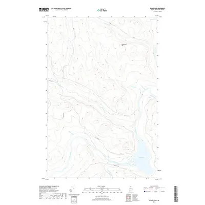
2018 Map of Round Pond
USGS Topo · Published 2018About this map
The Allagash River carves a deep valley through this Aroostook County landscape, punctuated by the broad waters of Round Pond in the southeast. The area is defined by a dense network of watercourses, including Savage Brook, Chase Brook, and Schedule Brook, which drain the elevated interior topography toward the main river channel. Dominating the northern horizon is Musquacook Mtn, a prominent landform that shapes the local drainage patterns for the surrounding Inn Rd and Boulevard Rd. Access through this timber-rich region is facilitated by several established routes like Blanchette Rd, which winds past Gamash Brook and Henderson Brook. The 2018 survey reveals the contemporary state of this remote river system, showing the winding paths of Croque Brook and Bogan Brook as they navigate the ridges and lowlands of the North Woods.
Find a feature on this map
13 named features on this map. Tap any name to fly to it.
Don’t see what you’re looking for? This feature index may not catch every label — zoom into the map to look around manually.
Map Details
Editions of this 2018 Round Pond Map
This is the sole edition of this map. No revisions or reprints were ever made.
Other maps of this area

1932 · Umsaskis Lake
USGS Topo · 1:48,000

1932 · Musquacook Lakes
USGS Topo · 1:48,000

1932 · Allagash Falls
USGS Topo · 1:48,000

1935 · Umsaskis Lake
USGS Topo · 1:62,500

1935 · Musquacook Lakes
USGS Topo · 1:62,500

1935 · Allagash Falls
USGS Topo · 1:62,500

1954 · Presque Isle
USGS Topo · 1:250,000

1955 · Round Pond
USGS Topo · 1:62,500

1956 · Allagash Falls
USGS Topo · 1:50,000

1958 · Presque Isle
USGS Topo · 1:250,000