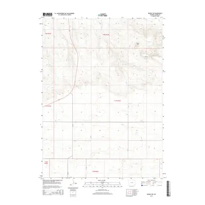
2015 Map of Round Top
USGS Topo · Published 2015About this map
Round Top and Flattop dominate the high plains of Laramie County on this survey, providing key topographical landmarks in a landscape defined by expansive ranching or agricultural sections. The drainage system is clearly etched into the terrain, with Herrick Cr and Mills Cr winding through the township lines of t18n r62w and t17n r62w. A network of county roads, including CR-149 and CR-152, forms a precise grid across the territory, connecting isolated homesteads to primary regional arteries like Highway 85. The map records a moment in the modern era where traditional land divisions of the Public Land Survey System remain the primary framework for navigation and property in this part of Wyoming.
Find a feature on this map
21 named features on this map. Tap any name to fly to it.
Don’t see what you’re looking for? This feature index may not catch every label — zoom into the map to look around manually.
Map Details
Editions of this 2015 Round Top Map
This is the sole edition of this map. No revisions or reprints were ever made.
Other maps of this area

1899 · Goshen Hole
USGS Topo · 1:125,000

1954 · Cheyenne
USGS Topo · 1:250,000

1958 · Cheyenne
USGS Topo · 1:250,000

1960 · Petsch Reservoir
USGS Topo · 1:24,000

1960 · Rocky Hollow
USGS Topo · 1:24,000

1960 · Meriden
USGS Topo · 1:24,000

1963 · Midway
USGS Topo · 1:24,000

1963 · Midway SE
USGS Topo · 1:24,000
1963 · Round Top
USGS Topo · 1:24,000

1963 · Midway SW
USGS Topo · 1:24,000