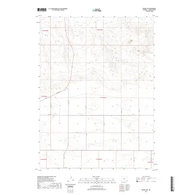
2017 Map of Round Top
USGS Topo · Published 2017About this map
Round Top and Flattop rise as prominent geological landmarks above the drainage basins of the high plains in this section of Laramie County. The landscape is defined by the ephemeral watercourses of Bull Spring Cr, Herrick Cr, and Mills Cr, which carve through the terrain as they flow toward the north and east. This era of the region’s development is characterized by a sparse, utilitarian road network established on the Public Land Survey System grid, which divides the township and range boundaries including t17n r62w and t18n r63w. Major transit corridors such as Torrington Rd and Albin Rd intersect the territory, connecting isolated ranching operations. The mapping of small county roads like Co Rd 150 and Co Rd 234 provides a precise record of the rural infrastructure supporting the eastern Wyoming livestock and agricultural economy in the early twenty-first century.
Find a feature on this map
26 named features on this map. Tap any name to fly to it.
Don’t see what you’re looking for? This feature index may not catch every label — zoom into the map to look around manually.
Map Details
Editions of this 2017 Round Top Map
This is the sole edition of this map. No revisions or reprints were ever made.
Other maps of this area

1899 · Goshen Hole
USGS Topo · 1:125,000

1954 · Cheyenne
USGS Topo · 1:250,000

1958 · Cheyenne
USGS Topo · 1:250,000

1960 · Petsch Reservoir
USGS Topo · 1:24,000

1960 · Rocky Hollow
USGS Topo · 1:24,000

1960 · Meriden
USGS Topo · 1:24,000

1963 · Midway
USGS Topo · 1:24,000

1963 · Midway SE
USGS Topo · 1:24,000
1963 · Round Top
USGS Topo · 1:24,000

1963 · Midway SW
USGS Topo · 1:24,000