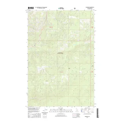
2017 Map of Roundtop
USGS Topo · Published 2017About this map
Clearwater National Forest dominates this section of the Idaho backcountry, where steep drainages and high ridgelines define the landscape. The prominent Beaver Ridge serves as a central spine, flanked by the valley of Brushy Fork to the north and the headwaters of Beaver Cr to the south. The small settlement at Roundtop provides a rare point of human activity in an area otherwise characterized by vast stretches of timber and the complex network of mountain streams including Crooked Fork, Storm Cr, and Twin Cr. Forest service access is limited to a few arterial routes like Beaver Ridge Rd 369 and Elk Meadows Rd. The map illustrates a modern wilderness management era, preserving the topographical relationship between high-altitude clearings like Beaver Meadows and the deep creek beds that feed into larger regional watersheds.
Find a feature on this map
18 named features on this map. Tap any name to fly to it.
Don’t see what you’re looking for? This feature index may not catch every label — zoom into the map to look around manually.
Map Details
Editions of this 2017 Roundtop Map
This is the sole edition of this map. No revisions or reprints were ever made.
Other maps of this area

1901 · Hamilton
USGS Topo · 1:125,000

1911 · Lolo
USGS Topo · 1:250,000

1912 · Missoula
USGS Topo · 1:125,000

1913 · Lolo
USGS Topo · 1:250,000

1956 · Hamilton
USGS Topo · 1:250,000

1959 · Hamilton
USGS Topo · 1:250,000

1960 · Hamilton
USGS Topo · 1:250,000

1964 · Hamilton
USGS Topo · 1:250,000

1964 · Lolo Hot Springs
USGS Topo · 1:24,000

1964 · West Fork Butte
USGS Topo · 1:24,000