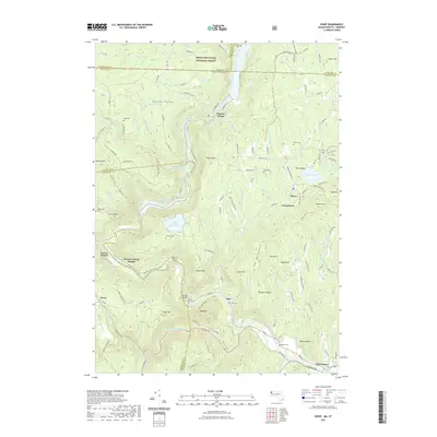
2021 Map of Rowe
USGS Topo · Published 2021About this map
Deerfield River carving and steep topographic shifts define this borderland where Massachusetts meets Vermont. The engineering legacy of the Hoosac Tunnel remains prominent, with the Hoosac Tunnel Station and Old Railroad Grade marking the historical transit corridor through the Hoosac Range. Local genealogy is well-preserved through numerous family burial sites, including the Nelson Family Cem and Cressey Cem. Small settlements like Monroe Bridge, Zoar, and Rowe are interconnected by winding mountain roads and ancient trails such as the Old Cyrus Stage Rd. The landscape is heavily managed for water and conservation, featuring the Upper Reservoir Bear Swamp and the Dunbar Brook Reservoir, all while sitting at the southern edge of the Green Mountain National Forest.
Find a feature on this map
139 named features on this map. Tap any name to fly to it.
Don’t see what you’re looking for? This feature index may not catch every label — zoom into the map to look around manually.
Map Details
Editions of this 2021 Rowe Map
This is the sole edition of this map. No revisions or reprints were ever made.
Other maps of this area

1886 · Greylock
USGS Topo · 1:62,500

1886 · Hawley
USGS Topo · 1:62,500

1889 · Wilmington
USGS Topo · 1:62,500

1890 · Hawley
USGS Topo · 1:62,500

1891 · Wilmington
USGS Topo · 1:62,500

1891 · Greylock
USGS Topo · 1:62,500

1893 · Greylock
USGS Topo · 1:62,500

1894 · Hawley
USGS Topo · 1:62,500

1898 · Bennington
USGS Topo · 1:62,500

1898 · Greylock
USGS Topo · 1:62,500