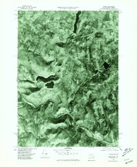
1975 Map of Rowe
USGS Topo · Published 1981About this map
The Deerfield River carves a deep, winding path through the northern Massachusetts highlands in the mid-1970s, anchoring industrial and transport nodes like Monroe Bridge and Zoar. This orthophoto map provides a clear aerial perspective on the region's complex water management and infrastructure, highlighting the Sherman Reservoir at the Vermont border and the Lower Reservoir to the south. The dramatic topography is punctuated by the engineering landmark of the Hoosac Tunnel, which enters the mountain near the river's bend. Small hamlets like Drury and the township of Rowe sit amidst dense forest cover, showing the settlement patterns of Franklin County before modern development altered the woodland character. The interplay between the steep river valley and the rail line at Charlemont illustrates the historical reliance on these natural corridors for movement through the Berkshires.
Find a feature on this map
10 named features on this map. Tap any name to fly to it.
Don’t see what you’re looking for? This feature index may not catch every label — zoom into the map to look around manually.
Map Details
Editions of this 1975 Rowe Map
This is the sole edition of this map. No revisions or reprints were ever made.
Other maps of this area

1886 · Greylock
USGS Topo · 1:62,500

1886 · Hawley
USGS Topo · 1:62,500

1889 · Wilmington
USGS Topo · 1:62,500

1890 · Hawley
USGS Topo · 1:62,500

1891 · Wilmington
USGS Topo · 1:62,500

1891 · Greylock
USGS Topo · 1:62,500

1893 · Greylock
USGS Topo · 1:62,500

1894 · Hawley
USGS Topo · 1:62,500

1898 · Bennington
USGS Topo · 1:62,500

1898 · Greylock
USGS Topo · 1:62,500