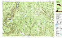
1990 Map of Rowe
USGS Topo · Published 1990About this map
The Deerfield River carves a deep valley through this northern Massachusetts borderland, anchoring a landscape where industrial infrastructure and mountain wilderness coexist. In the town of Rowe, the presence of a Nuclear Powerplant near Sherman Reservoir and the Sherman Dam reflects the 20th-century energy development of the region, while the Hoosac Tunnel to the west remains a significant engineering landmark of the rail era. Local history is well-preserved through numerous burial grounds such as Sherman Cem, West Cem, and North Cem, which trace the early families of settlements like North Heath and Adamsville. The terrain is characterized by high peaks including Adams Mtn and Blueberry Peak, much of which is protected within the Monroe State Forest and Mohawk Trail State Forest. Significant resource extraction is noted at the Davis Mine in the eastern portion of the quadrangle.
Find a feature on this map
90 named features on this map. Tap any name to fly to it.
Don’t see what you’re looking for? This feature index may not catch every label — zoom into the map to look around manually.
Map Details
Editions of this 1990 Rowe Map
2 editions found
Other maps of this area

1886 · Greylock
USGS Topo · 1:62,500

1886 · Hawley
USGS Topo · 1:62,500

1889 · Wilmington
USGS Topo · 1:62,500

1890 · Hawley
USGS Topo · 1:62,500

1890 · Greenfield
USGS Topo · 1:62,500

1891 · Wilmington
USGS Topo · 1:62,500

1891 · Greylock
USGS Topo · 1:62,500

1891 · Brattleboro
USGS Topo · 1:62,500

1893 · Brattleboro
USGS Topo · 1:62,500

1893 · Greylock
USGS Topo · 1:62,500