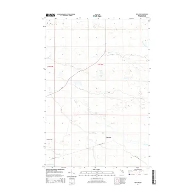
2014 Map of Roy Lake
USGS Topo · Published 2014About this map
The Tahquamenon River flows through the southern reaches of this Upper Peninsula landscape, a region defined by its complex network of seasonal creeks and scattered glacial lakes. The presence of Charcoal Grade Rd in the south provides a tangible link to the area's industrial past, tracing a path through the woods near Sixteen Cr and Lynch Lake. Modern access is primarily provided by M-123, which cuts diagonally across the northern townships toward the various interior waters.
Find a feature on this map
19 named features on this map. Tap any name to fly to it.
Don’t see what you’re looking for? This feature index may not catch every label — zoom into the map to look around manually.
Map Details
Editions of this 2014 Roy Lake Map
This is the sole edition of this map. No revisions or reprints were ever made.
Other maps of this area

1954 · Sault Sainte Marie
USGS Topo · 1:250,000

1956 · Sault Sainte Marie
USGS Topo · 1:250,000

1957 · Sault Sainte Marie
USGS Topo · 1:250,000

1958 · Sault Sainte Marie
USGS Topo · 1:250,000

1962 · Auger Lake
USGS Topo · 1:24,000

1968 · Muskallonge Lake SE
USGS Topo · 1:24,000

1968 · Betsy Lake SW
USGS Topo · 1:24,000
1968 · Betsy Lake South
USGS Topo · 1:24,000
1973 · Newberry
USGS Topo · 1:24,000
1973 · Roberts Corner
USGS Topo · 1:24,000