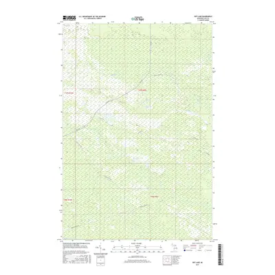
2017 Map of Roy Lake
USGS Topo · Published 2017About this map
The dense forests and wetland networks of Luce County define this remote landscape, captured during a 2017 survey by the U.S. Geological Survey. Surface water dominates the terrain, with Roy Lake and Quintus Lake at the center of an intricate hydrological system including Coyote Lake and Lynch Lake. The drainage pattern is driven by winding waterways such as Gimlet Creek and Murphy Creek, which eventually reach the notable Tahquamenon River at the southern boundary. Transportation through this wilderness relies on a sparse network of forest routes, most notably the Charcoal Grade Road, suggesting the area's history of logging and industrial resource access. Other primary access points like Skyline Road and Hunters Truck Trail provide the only significant pathways through the thick vegetation and complex marshlands characteristic of Michigan's Upper Peninsula.
Find a feature on this map
19 named features on this map. Tap any name to fly to it.
Don’t see what you’re looking for? This feature index may not catch every label — zoom into the map to look around manually.
Map Details
Editions of this 2017 Roy Lake Map
This is the sole edition of this map. No revisions or reprints were ever made.
Other maps of this area

1954 · Sault Sainte Marie
USGS Topo · 1:250,000

1956 · Sault Sainte Marie
USGS Topo · 1:250,000

1957 · Sault Sainte Marie
USGS Topo · 1:250,000

1958 · Sault Sainte Marie
USGS Topo · 1:250,000

1962 · Auger Lake
USGS Topo · 1:24,000

1968 · Muskallonge Lake SE
USGS Topo · 1:24,000

1968 · Betsy Lake SW
USGS Topo · 1:24,000
1968 · Betsy Lake South
USGS Topo · 1:24,000
1973 · Newberry
USGS Topo · 1:24,000
1973 · Roberts Corner
USGS Topo · 1:24,000