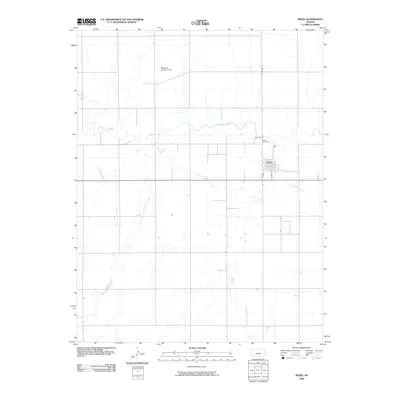
2009 Map of Rozel
USGS Topo · Published 2009About this map
Rozel serves as the primary hub for this Pawnee County landscape, centered on a traditional grid at the intersection of Main St and Pawnee St. The settlement is defined by its relationship with the meandering Pawnee River, which snakes across the northern half of the quadrangle. To the south, the winding path of Sawmill Creek carves through the agricultural plains, illustrating the drainage patterns that have historically shaped land use in this part of Kansas. Just north of the town center, the Rozel Cemetery stands as a significant point for genealogical research, while the presence of the Buckman Landing Strip in the northern reaches highlights the integration of light aviation into the rural economy. This survey documents the area's development during the first decade of the 2000s, reflecting a stable rural community built around water resources and regional transport routes.
Find a feature on this map
8 named features on this map. Tap any name to fly to it.
Don’t see what you’re looking for? This feature index may not catch every label — zoom into the map to look around manually.
Map Details
Editions of this 2009 Rozel Map
This is the sole edition of this map. No revisions or reprints were ever made.
Other maps of this area

1889 · Larned
USGS Topo · 1:125,000

1891 · Larned
USGS Topo · 1:125,000

1892 · Ness
USGS Topo · 1:125,000

1894 · Ness
USGS Topo · 1:125,000

1955 · Great Bend
USGS Topo · 1:250,000

1957 · Great Bend
USGS Topo · 1:250,000

1958 · Great Bend
USGS Topo · 1:250,000
1970 · Rozel
USGS Topo · 1:24,000
1970 · Sanford
USGS Topo · 1:24,000
1970 · Burdett
USGS Topo · 1:24,000