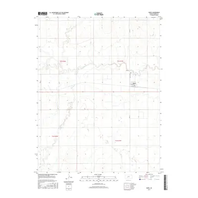
2015 Map of Rozel
USGS Topo · Published 2015About this map
The town of Rozel serves as the central hub of this Pawnee County landscape, situated where the high plains meet the winding corridor of the Pawnee River. The river's meanders create a distinct contrast with the rigid grid of the Public Land Survey System, which organizes the surrounding agricultural land into townships like t21s r20w and t21s r19w. Just north of the main settlement lies the Rozel Cem, a key landmark for genealogical research in this rural community. The hydrology of the area is further defined by the drainage of Sawmill Cr, which cuts through the southwestern sections of the quadrangle. Local transportation is anchored by a network of numbered and named roads, including W Edwards Ave and Saver Dr, which facilitate movement between the town and the outlying farms that define the regional economy.
Find a feature on this map
17 named features on this map. Tap any name to fly to it.
Don’t see what you’re looking for? This feature index may not catch every label — zoom into the map to look around manually.
Map Details
Editions of this 2015 Rozel Map
This is the sole edition of this map. No revisions or reprints were ever made.
Other maps of this area

1889 · Larned
USGS Topo · 1:125,000

1891 · Larned
USGS Topo · 1:125,000

1892 · Ness
USGS Topo · 1:125,000

1894 · Ness
USGS Topo · 1:125,000

1955 · Great Bend
USGS Topo · 1:250,000

1957 · Great Bend
USGS Topo · 1:250,000

1958 · Great Bend
USGS Topo · 1:250,000
1970 · Rozel
USGS Topo · 1:24,000
1970 · Sanford
USGS Topo · 1:24,000
1970 · Burdett
USGS Topo · 1:24,000