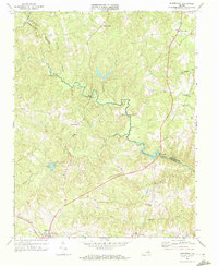
1968 Map of Rubermont
USGS Topo · Published 1972About this map
Victoria anchors the southwestern corner of this Virginia landscape, where the Norfolk and Western railroad tracks cut a prominent line through the Piedmont terrain. The Nottoway River meanders across the central portion of the map, defining the border between Nottoway and Lunenburg counties. This 1960s environment is characterized by a dense network of rural community centers and ecclesiastical sites, including Mt Zion Ch, Bethel Ch, and Laurel Hill Ch.
Find a feature on this map
34 named features on this map. Tap any name to fly to it.
Don’t see what you’re looking for? This feature index may not catch every label — zoom into the map to look around manually.
Map Details
Editions of this 1968 Rubermont Map
2 editions found
Other maps of this area

1891 · Farmville
USGS Topo · 1:125,000

1893 · Farmville
USGS Topo · 1:125,000

1947 · Roanoke
USGS Topo · 1:250,000

1953 · Greensboro
USGS Topo · 1:250,000

1954 · Greensboro
USGS Topo · 1:250,000

1955 · Chase City
USGS Topo · 1:62,500

1955 · Kenbridge
USGS Topo · 1:62,500

1958 · Crewe
USGS Topo · 1:62,500

1958 · Keysville
USGS Topo · 1:62,500

1959 · Roanoke
USGS Topo · 1:250,000