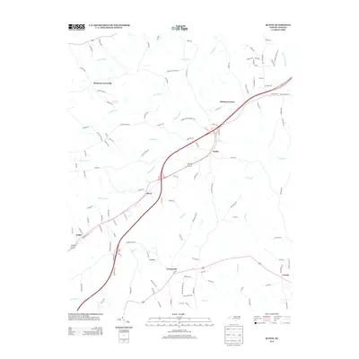
2013 Map of Ruffin
USGS Topo · Published 2013About this map
Ruffin serves as a central hub on this 2013 survey of Caswell and Rockingham Counties, where the modernized path of U.S. Route 29 and its business route cut through a landscape of historic Piedmont crossroads. The map illustrates a rural settlement pattern defined by proximity to significant watercourses like Wolf Island Cr and Lick Fork. While the primary highway facilitates regional transit, the surrounding secondary roads—such as Worsham Mill Rd and Bailey Farm Rd—preserve the footprint of older agricultural holdings and family-centered communities. To the southeast, Casville stands at a junction leading toward Hogans Cr, while northern reaches like Stephens Crossroads and Oakhaven Farms highlight the transition from traditional farming tracts to modern rural residential developments. Features such as Guerrant Springs provide a look at the natural hydrology that historically dictated the placement of these early homesteads.
Find a feature on this map
124 named features on this map. Tap any name to fly to it.
Don’t see what you’re looking for? This feature index may not catch every label — zoom into the map to look around manually.
Map Details
Editions of this 2013 Ruffin Map
This is the sole edition of this map. No revisions or reprints were ever made.
Other maps of this area

1923 · Danville
USGS Topo · 1:48,000

1924 · Draper
USGS Topo · 1:48,000

1925 · Danville
USGS Topo · 1:62,500

1926 · Draper
USGS Topo · 1:62,500

1944 · Draper
USGS Topo · 1:62,500

1953 · Greensboro
USGS Topo · 1:250,000

1954 · Greensboro
USGS Topo · 1:250,000

1962 · Greensboro
USGS Topo · 1:250,000

1965 · Danville
USGS Topo · 1:24,000
1965 · Brosville
USGS Topo · 1:24,000