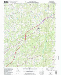
2002 Map of Ruffin
USGS Topo · Published 2002About this map
Ruffin serves as a focal point in this portion of North Carolina, where the landscape is defined by the headwaters of numerous creeks and a network of rural crossroads. The boundary between Rockingham Co Caswell Co runs through the eastern section, dividing small agricultural communities and family settlements. High ground is frequently occupied by community landmarks such as Lively Stones Ch, Mt Hermon Ch, and Wolf Island Ch, reflecting the area's deep-rooted local heritage.
Find a feature on this map
30 named features on this map. Tap any name to fly to it.
Don’t see what you’re looking for? This feature index may not catch every label — zoom into the map to look around manually.
Map Details
Editions of this 2002 Ruffin Map
This is the sole edition of this map. No revisions or reprints were ever made.
Other maps of this area

1923 · Danville
USGS Topo · 1:48,000

1924 · Draper
USGS Topo · 1:48,000

1925 · Danville
USGS Topo · 1:62,500

1926 · Draper
USGS Topo · 1:62,500

1944 · Draper
USGS Topo · 1:62,500

1953 · Greensboro
USGS Topo · 1:250,000

1954 · Greensboro
USGS Topo · 1:250,000

1962 · Greensboro
USGS Topo · 1:250,000
1965 · Danville
USGS Topo · 1:24,000
1965 · Brosville
USGS Topo · 1:24,000