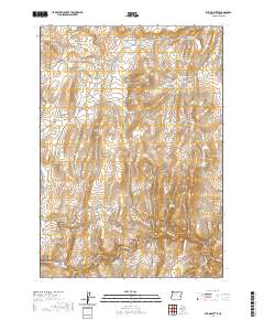
2020 Map of Rufino Butte
USGS Topo · Published 2020About this map
Rufino Butte rises over a high desert landscape in Malheur County, defined by its intricate network of ephemeral water management systems and remote rangeland. The map illustrates a dependence on livestock watering holes, featuring numerous named catchments such as Coyote Wells Reservoir, McConnell Reservoir, and Two Way Reservoir. The drainage patterns are dominated by Dry Cr, which carves the distinct Dry Creek Gorge in the southern sections of the quadrangle. Highlighting the importance of natural water sources in this arid region, several unique springs are identified, including the colorful Slim and Fatty Spring and the clustered Canyon Springs. Human intervention is limited primarily to ranching infrastructure, connected by the unpaved paths of Crowley Rd and the Dry Creek Cutoff.
Find a feature on this map
24 named features on this map. Tap any name to fly to it.
Don’t see what you’re looking for? This feature index may not catch every label — zoom into the map to look around manually.
Map Details
Editions of this 2020 Rufino Butte Map
This is the sole edition of this map. No revisions or reprints were ever made.
Other maps of this area

1955 · Boise
USGS Topo · 1:250,000

1958 · Boise
USGS Topo · 1:250,000

1962 · Boise
USGS Topo · 1:250,000

1972 · Tims Peak
USGS Topo · 1:24,000
1972 · Wall Rock Springs
USGS Topo · 1:24,000

1972 · Alder Creek
USGS Topo · 1:24,000

1972 · Avery Creek
USGS Topo · 1:24,000

1972 · Rufino Butte
USGS Topo · 1:24,000

1972 · Copeland Reservoirs
USGS Topo · 1:24,000
1972 · Hurley Flat
USGS Topo · 1:24,000