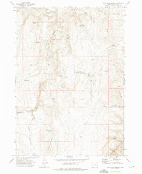
1972 Map of Wall Rock Springs
USGS Topo · Published 1975About this map
Juniper Ranch and the West Page Cabin spring sit at the center of this high desert landscape in Malheur County, recorded just as photogrammetric methods from 1971 aerial surveys were standardizing modern topographic detail. The terrain is defined by a sophisticated network of water management features, including Shaeffer Butte Reservoir, Fectley Reservoir, and Sometime Reservoir, illustrating the critical importance of water storage for livestock in this arid region. Named landmarks like Knottingham Butte and the Owyhee Breaks provide significant elevation changes, while numerous water sources such as Wall Rock Springs and Mineral Springs dot the drainage basins of Wall Rock Creek and Juniper Creek. A lone Prospect near Quartz Mtn suggests early mineral interest, though the primary character of the land remains centered on ranching infrastructure and remote springs like Black Bull Springs.
Find a feature on this map
36 named features on this map. Tap any name to fly to it.
Don’t see what you’re looking for? This feature index may not catch every label — zoom into the map to look around manually.
Map Details
Editions of this 1972 Wall Rock Springs Map
This is the sole edition of this map. No revisions or reprints were ever made.
Other maps of this area

1906 · Mitchell Butte
USGS Topo · 1:125,000

1955 · Boise
USGS Topo · 1:250,000

1958 · Boise
USGS Topo · 1:250,000

1962 · Boise
USGS Topo · 1:250,000

1967 · Diamond Butte
USGS Topo · 1:24,000

1967 · Twin Springs
USGS Topo · 1:24,000

1967 · Quartz Mtn Basin
USGS Topo · 1:24,000

1972 · Cedar Mountain
USGS Topo · 1:24,000

1972 · Big Mud Flat
USGS Topo · 1:24,000

1972 · Rufino Butte
USGS Topo · 1:24,000