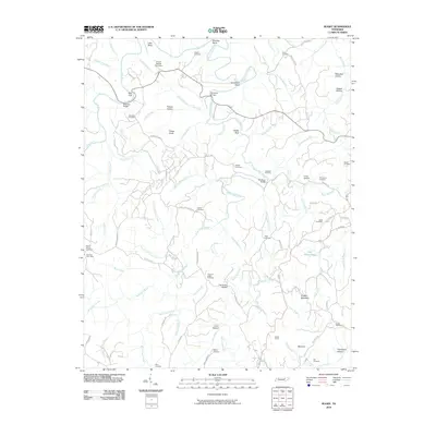
2010 Map of Rugby
USGS Topo · Published 2010About this map
Clear Fork and White Oak Creek carve a complex path through this Tennessee landscape, creating prominent geological features like Little Bend, Meeting Bend, and Horseshoe Bend. The terrain is characterized by numerous hollows, including Polecat Hollow and Mary Bull Hollow, while Potato Knob and Grassy Mountain rise above the drainage networks. This area is notably dense with family-named burial grounds and small community landmarks, reflecting a deep-rooted rural settlement pattern.
Find a feature on this map
103 named features on this map. Tap any name to fly to it.
Don’t see what you’re looking for? This feature index may not catch every label — zoom into the map to look around manually.
Map Details
Editions of this 2010 Rugby Map
This is the sole edition of this map. No revisions or reprints were ever made.
Other maps of this area

1895 · Wartburg
USGS Topo · 1:125,000

1896 · Wartburg
USGS Topo · 1:125,000

1935 · Gobey
USGS Topo · 1:24,000

1935 · Pilot Mountain
USGS Topo · 1:24,000

1936 · Twin Bridges
USGS Topo · 1:24,000

1943 · Twin Bridges
USGS Topo · 1:24,000
1945 · Twin Bridges
USGS Topo · 1:24,000
1946 · Gobey
USGS Topo · 1:24,000
1946 · Pilot Mountain
USGS Topo · 1:24,000

1952 · Helenwood
USGS Topo · 1:24,000