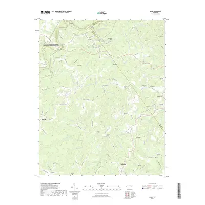
2019 Map of Rugby
USGS Topo · Published 2019About this map
Rugby, a historic Victorian colony, sits at the boundary of Morgan, Fentress, and Scott counties, surrounded by the deep drainages of the Big South Fork National River and Recreation Area. The landscape is defined by the sharp meanders of the Clear Fork river and White Oak Creek, which have carved distinctive terrain features like Horseshoe Bend and Little Bend. Numerous family-named cemeteries, including Nydeck Cem and Griffith Cem, are scattered across the ridges, providing a rich record of the area's ancestral settlements such as Brewstertown and Burrville. To the south, the rail corridor near Sunbright features the Sixteen Tunnel, illustrating the engineered path required to navigate the Cumberland Plateau's geography. This survey documents the intersection of preservation and rural life, from the protected riverside lands to the active small communities of Huffman and Glenmary.
Find a feature on this map
120 named features on this map. Tap any name to fly to it.
Don’t see what you’re looking for? This feature index may not catch every label — zoom into the map to look around manually.
Map Details
Editions of this 2019 Rugby Map
This is the sole edition of this map. No revisions or reprints were ever made.
Other maps of this area

1895 · Wartburg
USGS Topo · 1:125,000

1896 · Wartburg
USGS Topo · 1:125,000

1935 · Gobey
USGS Topo · 1:24,000

1935 · Pilot Mountain
USGS Topo · 1:24,000

1936 · Twin Bridges
USGS Topo · 1:24,000

1943 · Twin Bridges
USGS Topo · 1:24,000
1945 · Twin Bridges
USGS Topo · 1:24,000
1946 · Gobey
USGS Topo · 1:24,000
1946 · Pilot Mountain
USGS Topo · 1:24,000

1952 · Helenwood
USGS Topo · 1:24,000