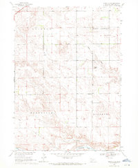
1969 Map of Rushville NE
USGS Topo · Published 1972About this map
Niobrara River flows through the southern reaches of this Sheridan County landscape, anchoring a rural topography defined by the drainages of Rush Creek and Sand Draw. Surveyed in the late 1960s as part of the Missouri River Basin development program, the area maintains a sparse, agricultural character organized by township lines. Rural education sites like Long View Sch and Fairview Sch are documented alongside the prominent landmark of Lone Butte, providing specific points of interest for those tracing the historical footprint of ranching and settlement north of the Niobrara boundary. The map captures the quiet transition between the West Gordon and Rushville districts, where local roads follow the section lines across the high plains terrain.
Find a feature on this map
11 named features on this map. Tap any name to fly to it.
Don’t see what you’re looking for? This feature index may not catch every label — zoom into the map to look around manually.
Map Details
Editions of this 1969 Rushville NE Map
This is the sole edition of this map. No revisions or reprints were ever made.
Other maps of this area

1955 · Alliance
USGS Topo · 1:250,000

1957 · Alliance
USGS Topo · 1:250,000

1958 · Alliance
USGS Topo · 1:250,000

1966 · Rushville
USGS Topo · 1:24,000

1966 · Rushville SW
USGS Topo · 1:24,000

1969 · Rushville 4 SW
USGS Topo · 1:24,000

1969 · Gordon
USGS Topo · 1:24,000

1969 · Clinton
USGS Topo · 1:24,000

1969 · Clinton SW
USGS Topo · 1:24,000

1969 · Rushville SE
USGS Topo · 1:24,000