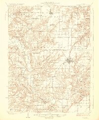
1926 Map of Rushville
USGS Topo · Published 1926About this map
Rushville serves as the focal point of this 1920s survey, showing the town as a vital regional hub along the Chicago Burlington and Quincy railroad. The surrounding landscape of Schuyler and Brown counties is defined by an incredibly dense network of rural infrastructure, where nearly every section of land is served by a local schoolhouse or church. Significant landmarks like White Sulphur School, Olive Branch School, and Bethany Church illustrate the distributed nature of early 20th-century Illinois farm life. The terrain is deeply carved by the meandering path of Crooked Creek and its many tributaries, such as Missouri Creek and Sugar Creek, which dictate the placement of settlements like Ripley and Littleton. This map provides a clear view of the transition from the upland prairies to the dissected valley of Dutch Ridge before modern highway development reshaped the county.
Find a feature on this map
84 named features on this map. Tap any name to fly to it.
Don’t see what you’re looking for? This feature index may not catch every label — zoom into the map to look around manually.
Map Details
Editions of this 1926 Rushville Map
2 editions found