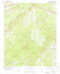
1971 Map of Russellville
USGS Topo · Published 1973About this map
The rolling Anson County uplands are defined here by the headwaters of Brown Creek and Jones Creek in the early 1970s. The northern edge of the landscape is traced by the Seaboard Coast Line railroad, which passes through the community of Russellville and near a local Drive-in Theater. Further west, the terrain rises toward Gordon Mountain and Becky Hill, punctuated by small rural congregations such as New Grove Ch and Poplar Hill Ch. Evidence of local industry and infrastructure is visible at the Quarry near Little Brown Creek and the State Prison Camp located south of the rail line. This survey captures a specific rural network of family-named creeks and churches, providing a detailed record of the area before modern development altered these traditional community hubs and travel corridors.
Find a feature on this map
33 named features on this map. Tap any name to fly to it.
Don’t see what you’re looking for? This feature index may not catch every label — zoom into the map to look around manually.
Map Details
Editions of this 1971 Russellville Map
This is the sole edition of this map. No revisions or reprints were ever made.
Other maps of this area

1941 · Spartanburg
USGS Topo · 1:250,000

1953 · Spartanburg
USGS Topo · 1:250,000

1953 · Charlotte
USGS Topo · 1:250,000

1954 · Charlotte
USGS Topo · 1:250,000

1956 · Ansonville
USGS Topo · 1:24,000

1956 · Wadesboro
USGS Topo · 1:24,000

1960 · Charlotte
USGS Topo · 1:250,000

1960 · Spartanburg
USGS Topo · 1:250,000

1962 · Charlotte
USGS Topo · 1:250,000

1963 · Spartanburg
USGS Topo · 1:250,000