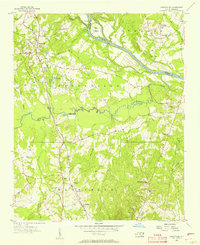
1956 Map of Ansonville
USGS Topo · Published 1957About this map
Ansonville serves as the primary upland hub on this mid-century survey, situated west of the wide Pee Dee River. The landscape is defined by the winding course of Brown Creek and its many tributaries, such as Cabbage Branch and Palmetto Branch, which carve through the rural terrain. Connectivity during this era relied on the Winston - Salem Southbound railroad and river crossings like the Old Leak Ferry near Leak Island. A network of community landmarks provides significant detail for genealogists, including several rural schools like the Rosenwald Sch and Birmingham Hough Sch, along with numerous country churches such as Salem Ch and Garris Grove Ch. Near the southern boundary, the Wadesboro Airport and the settlement of Pinkston mark the transition toward the neighboring county seat, illustrating the mid-fifties balance between traditional river-valley agriculture and modernizing transportation.
Find a feature on this map
44 named features on this map. Tap any name to fly to it.
Don’t see what you’re looking for? This feature index may not catch every label — zoom into the map to look around manually.
Map Details
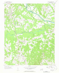
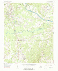
Editions of this 1956 Ansonville Map
Other maps of this area

1941 · Spartanburg
USGS Topo · 1:250,000

1942 · Troy
USGS Topo · 1:125,000

1942 · Rockingham
USGS Topo · 1:125,000

1953 · Florence
USGS Topo · 1:250,000

1953 · Raleigh
USGS Topo · 1:250,000

1953 · Spartanburg
USGS Topo · 1:250,000

1953 · Charlotte
USGS Topo · 1:250,000

1954 · Charlotte
USGS Topo · 1:250,000

1954 · Florence
USGS Topo · 1:250,000

1954 · Raleigh
USGS Topo · 1:250,000